


Donna Buang Walking Track
Whether you’re training for a seriously steep overseas trek a la Kokoda or Kilimanjaro or just want to complete the best mountain climb close to Melbourne, the Mount Donna Buang Walking Track is for you.
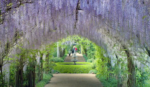
Donna Buang boasts enough natural beauty in its own right to guarantee it is a bushwalking gem that can be done at a leisurely pace. However, shooting up 1170-vertical metres in 9km, the Track comes into its own as a hill training venue.
Located only an hour (80km) from Melbourne’s CBD, the sheer slopes of the mountain deliver an ascent profile that gets lungs bursting and thighs burning, making it prime training ground, especially for hikers heading to Kokoda in Papua New Guinea or to overseas mountain summits. Indeed, Donna Buang’s jungle-like environment make it the perfect Kokoda preparation.
Those tackling its length rise up through towering mountain ash and ancient myrtle beech trees, pushing on into a dense rainforest jungle populated by gigantic tree ferns. The trail reaches Mount Victoria before nearing Donna’s summit (1245m), the prior saddle featuring a mystic atmosphere, especially when the mist rolls in, as it often does.
The finale is stepping up the viewing tower, a 21m rise that on a clear day delivers views across the Upper Yarra Valley.
Quicklook
| Trail | Donna Buang Walking Track |
| Activity | Walk or Run |
| Type | One way / Out and Back |
| Grade (if available) | Difficult; TrailScore technical Black 38/45, TrailScore general Black 8/10 |
| Start | Warburton Main St |
| Finish | Mt Donna Buang Viewing Tower / Summit |
| Distance | 9km (one way) / 18km (out and back) |
| Ascent | 1170 m (one way) |
| Descent | 70 m (one way) |
| Max Elevation | 1265 m |
| Features | The best hill climb close to Melbourne, steep single track, lush tree fern forests, gigantic mountain ash and myrtle beech, Mt Donna Buang Summit and viewing platform |
| Facilities | Toilets: Warburton township, Donna Buang Summit, 10 Mile Picnic Area (accessible en route), Rainforest Gallery (car access on return, Donna Buang Rd), Car parking: Warburton township, Donna Buang Summit, 10 Mile Picnic Area |
| Notes | Best completed in summer and shoulder seasons; muddy, slippery, potentially snowbound and difficult going in winter; car shuttle required if walking one way |
Run / Walk it
- You can begin the Donna Buang Walking Track from anywhere in Warburton, but we recommend a coffee or tea and sustenance from one of the many Main St cafes before departing. From the Main St, drop down the alley opposite the police station and turn left at the river to head west towards Story Reserve.
- This will get you to the iconic and very photogenic Swing Bridge located beside the tennis courts. Cross it, taking note of the extra bounce in your step as you run.
- On the other side of the river turn left, running riverside through the park until you are opposite Martyr Rd, a bitumen road you can’t miss – it’s the one blasting sharply up the mountain side, across Dammans Rd. Known as one of the steepest suburban streets in the Southern Hemisphere (it has cousins in Tasmania and New Zealand), Martyr Rd is a favourite challenge for hill climbing cyclists with its 62m vertical ascent in only 300m giving a 19% gradient. Try running it!
- Push on to the very top of Martyr Road. Where it turns sharply right there is a small singletrack entrance signposted ‘Donna Buang Walking Track’.
- The trail drops down a small gully before rising up again alongside a fenced paddock. Nearing the top, be sure to look back for magnificent views across the Warburton township.
- The trail turns right along the top of the paddock before popping runners out on the O’Shannassy Aqueduct Trail (which itself forms part of an excellent ride/run/walk route).
- Cross over O’Shannassy Aqueduct Trail and push back into the thick green bush. The trail cinches across the incline some before turning defiantly up, becoming quite steep.
- You can’t get lost on, really, the trail leading through the stunning mountain ash bushland for 3.5km (from the Aqueduct Trail) before punching out on to the sealed Donna Buang Rd.
- Look straight across and pick up a management vehicle track (gated) that will lead you up toward Mt Victoria and its communications towers.
- To the rear of the radio installation clearing, pick up the singletrack again, the route undulating through spectacular forest canopy above a carpet of low ferns.
- You will come across a junction, the trail left heading down to 10 Mile Picnic Area and car park (facilities available). Continue on straight to pass some ruins before exiting into the summit car park. It is well worth making the effort to climb the final 21m of stairs to catch a view (pending clouds!) from the top of the viewing tower.
Alternative
For an easier, shorter run that does not require a car shuffle, drive to the summit car park. Run back along the trail towards and over Mt Victoria, eventually popping out on Mount Donna Buang Rd. Walk roadside uphill for approximately 1km until you reach the 10 Mile Picnic Area. Pick up the linking trail at the rear of the car park taking you back on to the main Donna Buang Walking Track you came down on. Run back to the summit. Approximately 6km.

Walks eGuide
The Walks eGuide features over 200 walks and trails in the Dandenong Ranges and Yarra Valley. Covering all ability levels, whether your walk is dog-friendly or where to find your nearest toilet is covered in the Walks eGuide. At $15, it's a steal so grab your copy now!